Along the almost 3-mile long Arcade-Cripple Creek Trail Project alignment, there are a total of 629 trees (in both Citrus Heights and Orangevale) within the immediate vicinity of the trail. The overall goal of the project is to preserve as many trees as possible as trees, among other benefits, help to ensure a shaded trail for all to enjoy. However, many trees will require removal due to their existing poor condition. In addition, other trees will be pruned under the direction of arborists to help preserve and maintain safe walking and biking clearances. Finally, some trees will require removal due to trail construction.
Pruning:
As part of the overall project, some trees will require pruning. Pruning will remove specific branches or stems in an effort to benefit the health of the entire tree. Removal of dead, damaged and diseased branches prevents insect and other non-beneficial organisms from entering the tree. Thinning a dense canopy on a tree will increase air and sunlight, providing increased health and resulting in fewer tree disease problems. Pruning trees also helps them grow and mature in a healthy way in an effort to preserve the trees as long as possible.
Removal of Dead or Dying Trees:
Unfortunately, numerous trees along the Arcade-Cripple Creek Trail Project alignmnt have died or are diseased beyond recovery requiring removal for safety purposes. Some dead trees will be removed, others will remain in place as part of the natural environment and Eco-system.
Removal of Trees for Trail Construction:
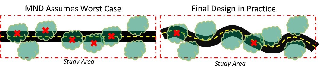
During the preliminary engineering and environmental review phase of the project, the City utilized conservative estimates to determine the potential for trees to be removed as part of the project. The purpose of this approach is to allow flexibility in the trail alignment during design. Although this seems counterintuitive, assuming the worst case scenario allows the city the ability to minimize the environmental impact. By assuming the worst case scenario, the design team is able to fine-tune the trail alignment and design without setting constraints during the conceptual phase. The ability to meander the trail from the concept allows for the flexibility to develop the best design, using detailed information and minimize tree impacts.
At the time of the environmental document and conceptual design, a total of 302 trees were identified to be removed as a result of the Arcade-Cripple Creek Trail Project. As part of the 95% design plans, that number has been reduced to 80 protected trees and 41 non-protected trees; a 60% reduction in the original tree removal quantity. In addition, the design team is working to develop design details to reduce that number even further.
As illustrated below, the environmental document for the Arcade-Cripple Creek Trail Project assumed a wide area of removal; whereas, in actuality, the trail will meander or utilize other design approaches to greatly reduce tree impacts.
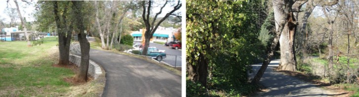
The images below illustrate design techniques that will enable preservation of nearby trees. The use of small retaining walls, meandering trail alignment, and narrowing short stretches of trail are examples of opportunities the city is considering during final design.
Any work conducted within the dripline of any tree to remain will be monitored by an arborist to ensure best-practices
are followed to minimize the impact of construction on these trees.
The project goal is to preserve as many trees as possible. Any trees that are removed will require replacement trees to offset the impact of the project. Replacement trees will be planted along the trail corridor and nearby parks as mitigation. Trees planted as part of mitigation are required to be monitored by an arborist for three years following installation to ensure they are able to thrive.